
Wednesday, February 24, 2010
More Photos from the First Annual Throw In, Throw Down
Wednesday, February 17, 2010
Tasmania
"If we can revise our attitudes towards the land under our feet; if we can accept a role of steward, and depart from the role of conqueror; if we can accept the view that (hu)man(ity) and nature are inseparable parts of the unified whole--then Tasmania can be a shining beacon in a dull, uniform, and largely artificial world." Olegas Truchnas, 1971
My idea for a bicycle tour in, around, or near Australia began with visions of New Zealand. But given my lack of luck with touring bikes, touring gear and airplanes, I decided it would be prudent to take a boat to some closer but equally exotic island. Thus, the 2010 Tour of Tasmania was born.
Initially planned as a solo adventure, talk of the tour attracted a lot of attention at Melbourne Bike Polo sessions. One became two; two became four...and eventually, four became six. And so, with visions of (not so) distant mountains fueling our aspirations, we got crackin' on the packin'.

I was fortunate to score a loaner bicycle from my friend Thorin, a Mongoose Randonneur outfitted with a Tubus rear carrier and Blackburn front rack. After installing a 12-32 8-speed rear cassette, the bike was ready to take on the Tasmanian terrain.
After sorting all my equipment the night before the tour, I packed up four panniers and a rear ruck sack with heaps of equipment. The final weight? Bike, bags, and gear combined to create a 50 kilo (110 pound) monstrosity. In all of it's glory:

I met Pete outside my house in Fitzroy North at 7 a.m. sharp, and we quickly set out for the Spirit of Tasmania Ferry stop in Port Melbourne.
Now, when I was young, I couldn't read and ride in a car. I suffered from motion sickness, but when I reached adolescence the tendency to become sick while reading in a car ebbed a bit. I thought I had, somehow, defeated motion sickness with pure will-power. In Denmark, I took a 40-minute fairy from the small island of Lolland to the center island of Fyn without any motion related issues...But after the Spirit of Tasmania pulled out from the well-protected confines of Port Philip into the infamously choppy waters of the Bass Strait, I knew my motion sickness was back with a vengeance.
Realizing I was about to lose my cookies, I headed to the deck for some fresh sea air. That didn't help. I wandered into the gift shop, green in the face, and a sales clerk just immediately passed me the sea sick pills. I quickly popped them into my mouth, and found a soft bench to stretch out on. Four hours later, I woke up to a view to see the island--and it's mountains--within sight.
Devonport
We rolled into the port town of Devonport at about half past 6. I carried a couple panniers for our friend Bec, who met us at the boat when we arrived. So, in total, I arrived with 6 panniers. Reduced to 4, we headed for the local watering hole for a stout meal and some adult beverages.
Deciding to camp beside the ocean just out of town, we began our hobo adventure.

Waking up we packed up camp (seen above) and prepared to head towards Boat Harbour, some 100 k down the road. As we ambled along, hitting multiple coffee shops in Devonport before actually deciding to leave, we ran into a European ex-pat out for his morning ride. Looking like he'd just emerged from 1987, Wolfgang showed as an alternate route out of Devonport. Turns out it was the hilly route.

Above, everyone recovers as Wolfgang tells stories of local cycling lore. Everything about him was 1987, including his Miyata triple butted racing frame with internally routed cable housing. Promising a wonderful fish and chip shop in Ulverstone, Wolfgang led us along a hillacious highway--and little did I know, it was only a sign of things to come.
As the first day of riding continued, we made it to the fabled town of Penguin, where everything seems to have a penguin--including the town square. Here's the lot of us, fully clad in touring gear and standing before a mighty (asbestos filled) penguin.

Because we were living like hobos, we would often rock up to a coffee shop, buy a coffee, and then pull out lunch makings from our panniers. As I made a cucumber, cheese and tomato sandwich in front of Penguin's finest coffee stop, I noticed a man glaring hard at me through the plate glass window. With stories of Tasmanian rednecks flashing through my mind, I figured it was best to just ignore the stare, focusing mostly on my mates and the thin slices of cucumber I was making.
Suddenly, the man emerges from the coffee shop and yells, "Hey Mate!" Pointing to the cucumber, he says, "you know you couldn't even shove that thing down a pig's throat." "Ha," I laughed, "I guess not." A bit shocked but mostly entertained, we all had a mighty laugh. Turns out pigs don't eat cucumbers.
After a tenacious first day, Leigh worried about his knee, losing two of our mates as they detoured to see the Table Cape, we descended down a massive hill into the surfing village of Boat Harbour. Meaning, the next morning a 12 percent, 3 kilometer climb would greet us. Good thing we ate our Wheaties.
The Road from Boat Harbor to Stanley
Excited about the second day of the tour, a hundred kilometers under our belt, we aimed for the not so distant coastal town of Stanley. Along the way we passed a cyclist heading the opposite direction. We stopped, of course, and had a chat about all things bike related. A touring cyclists from Sweden with excellent English (of course), he told us he'd gone as far as Stanley before deciding to head back the way he came. Speaking with a bit of McDonalds brown paper bag on his nose to guard the tip against the Tasmanian sun ('you find these everywhere, and they work so well,' he claimed), he told us he wasn't interested in going down the west coast. "The local's say there is nothing going on there." "True," I said. "Just wilderness. Which is exactly why we're heading that way." Really, he later confessed, he wanted to see the final match of the Australian Open. Fair enough. Passing good wishes, we went our separate ways.
A primary stop for tourists on the Tasmanian northwest coast, Stanley's big claim to fame is the Nut, a giant piece of rock at least 500 meters tall with one heck of a view. We had a climb, and enjoyed the view from a variety of angles.
A primary stop for tourists on the Tasmanian northwest coast, Stanley's big claim to fame is the Nut, a giant piece of rock at least 500 meters tall with one heck of a view. We had a climb, and enjoyed the view from a variety of angles.


Stanley, in all of it's expansive glory.


Once on top of the Nut, one can stroll on a path that winds all around it's edges and through its heart. From its windy, scrubby top we descended to a thickly wood bush filled with paddymellons (small marsupials). Unfortunately, they all hopped in mid-shot, so I've none to share here.

I was pretty excited about this giant lobster. Though it looks a bit menacing, I can assure you it was quite tame. The chips we had from inside the seafood shop were a bit deceptive...A medium turned out to be about a square meter of fried golden goodness. And being that each of us ordered a medium, the sea gulls ended up with quite a treat before it was all said and done. As we fed the seagulls, we came up with a record label: "Do a Record Bro, Recordings." We also came up with about two dozen album names, at least one hundred song titles, and about 20 B-sides. Unfortunately, Pete took notes on the madness--and he is in the middle of the Tasmanian bush as I type. Probably sleeping soundly, living the life most of us dream about. Can't wait to see that notebook.
Our third full day of touring took us through the little town of Smithton. We stopped at a supermarket for some provision and Leigh made friendly with the locals.

We passed an absolutely amazing river on day three with a strange and ironic name: Detention. Pictured below, the Detention River may have some of the most beautiful water I've ever seen.

As we prepared to depart Smithon, the beauty of the Detention contrasted with the plumes of smoke that slowly filled the horizon. The farther from Smithton we went, the thicker the smoke became. Soon we we're showered with soot and ash.

We quickly consulted the map as we decided whether or not to go on. Previously, we had stopped to talk with a local we met alongside the road. With a Boag's Draught in his hand, clearly not the first that day, he encouraged us to head on towards Marrawah--a city just south of Montagu--the town towards which we were heading and from where the smoke was emerging.


Ultimately, we decided to turn the troops around and head for brighter, less smoke clotted skies. Wise decision, I reckon. Sunny skies, thick woods and slow inclines greeted us as we got closer and closer to Marrawah.

Just in case there was any doubt, we left a reminder for our friends: the road stretched out onward and upward.
A notable photo from outside Marawah.

The Edge of the World
From Marawah, we headed towards the "Edge of the World," the northern-most tip of Tasmania's west coast, Arthur River. Tassy's west coast play's host to one edge of the longest un-interrupted expanse of ocean in the world: from South America to Tasmania, wind and waves can move uninhibited. Photos were definitely in order.

And photos of photos.

Here we have the complete crew, in all of our charismatic charm. From left to right we've got yours truly, Pete, Bec, Chuck, Leigh and Chris.

There were quite a few fisherman at the end of the world, a surprising fact for me. But this photo is quite typical of Tassy's west coast, amazing coast line with old, weather rocks amidst stunning bays.
The Tarkine Wilderness
Significant for more than one reason, Arthur River is the end of the road. Well, the paved road anyway.

The sign on the left reads "gravel road." Here, we're preparing to leave the comfort of asphalt for the contours of the Western Explorer, a 150 k stretch of un-sealed road through the Tarkine Wilderness.
 By the end of the day, I was still smiling. But then again, we'd only done about 25k on the gravel. The best, or worst depending on your perspective, was yet to come.
The lot of us camped beside the Frankland River that evening on a four wheel drive track that veered off of the main road.

We set up barriers at the end of the trail just in case someone had a mind to barrel through the trail at 3:45 a.m.
Beginning the next day of the tour with a climb up from the Frankland and back into the Tarkine, we had a quick stop at a visitor's plaque by the side of the road.


Harsh indeed. Mostly, the Tarkine was extraordinarily exposed, wide open to the wind and sun. It was difficult to find shade. Impossible at times.

Our strategy was to follow the smoothed out sections of road created by car tires. You can see a couple good lines here. The only trouble with following the car tracks is the corrugation...over time the cars would created raised areas and ruts running perpendicular to the road. A smooth line could become hell in 5 meters.
Soon, we began to see cryptic messages from our mates in the gravel.

"Bro" quickly became a theme for the trip. Everyone was bro, including our female friend Bec.

SFS. Two four letter words, one sandwiched between the other, that became a sort of catch all phrase in troubling times.

Pete's bike leaned against a kilometer marker in the middle of the wilderness. The land takes back everything eventually, as seen here with the moss encroaching on the reflector.

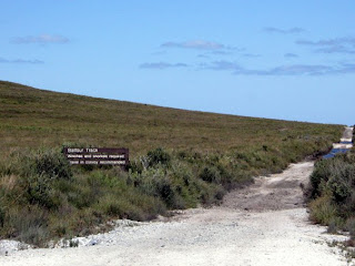
A rest break on the Tarkine did not include shade. Just nuts and dried fruit in the middle of the road. That was about the best we could do. Here we're stopped close to the Balfour turn-off, a road leading to an abandoned mining town with hulks of rusted out equipment and boarded up store fronts.
We camped on the Donaldson River after our first full day in the Tarkine. I was knanckered--beyond comprehension tired, actually. I lost my favorite Cateye head light to all the bumps and ruts without even noticing.

I definitely drank un-treated water out of this river. And it was amazing. Best of all, I'm still alive! Most of the wild rivers in Tasmania are fine for drinking...or so my friends have explained.
Towards the end of our second day in the Tarkine, we approached the old mining town of Corrina. Expecting a small hole in the wall visitors center with little to no provisions, we were shocked to find a pub, restaurant and campground at Corrina, where it's necessary to take a barge across the expansive and fast-moving Pieman river. Enjoying a couple Guinness, I played ping pong with Chris until dinner. Setting up our stoves on a picnic table near the river, I don't think our hobo tactics won the goodwill of our friends in Corrina. Hoping to buy a bit of good will by paying for camping, we found ourselves consigned to a rocky slope unfit for tent pegs. Happily, we left Corrina in Pete's rear-view mirror.

Not so happily, we started the day with an 8 k climb up from the Pieman. Fueled by the fact that paved road lay ahead, we determinedly slogged up the hill, one pedal stroke at a time.

And indeed, the gravel met the asphalt some 12 k from Corrina. Beautiful...but bittersweet. Sensing a big piece of our adventure had come to an end, we turned our handlebars towards the silver mining town of Zeehan.
For some of us, though, it was a good thing we hit the asphalt.
The road was a bit tough on Leigh's Specialized Armadillo tires:


Here, the tire tread had torn completely away from the tire casing, leaving an exposed strip of Kevlar that quickly wore away. The road couldn't have come a moment too soon.
Emergin from the Tarkine: Zeehan
Arriving in Zeehan, Bec and Pete decided to head for the Henty Dunes, a section of hard-packed beach sand that was somewhat suitable for bicycle riding. Chris, Leigh and I headed for a spot close to Zeehan recommended by a fellow me met in town. After a couple games of pool at the Zeehan Central Hotel, we headed for the Spray Mine site.

Raining for the first time of the tour, we passed through this tunnel created to carry miners on a tram from the town to the mine entrance.

The exterior workings of the mine were still evident just beside our camp. Chris, the gentleman we met in town, told us he would often go with a group to explore the mines. Bound together as a group of three, if someone fell into a shaft covered by a meter of mud the others could pull him out. "All the rocks around here will be rusty when you get up in the morning," he said. "It's all ore." He was right.

We set up our hobo camp--and our hobo tarp in the shadow of a mountain.

Our last night together was spent camping (somewhat illegally) at People's Park in the oceanside town of Strahan. The night before we left included some amazing banter and insightful comments, alongside other behavior that will just have to left to the imaginations or experiences of those that understand last nights with best friends.

...And then there were two
Stay tuned for the conclusion of the Epic Tasmanian Tour....
Stay tuned for the conclusion of the Epic Tasmanian Tour....

Monday, February 15, 2010
Subscribe to:
Posts (Atom)